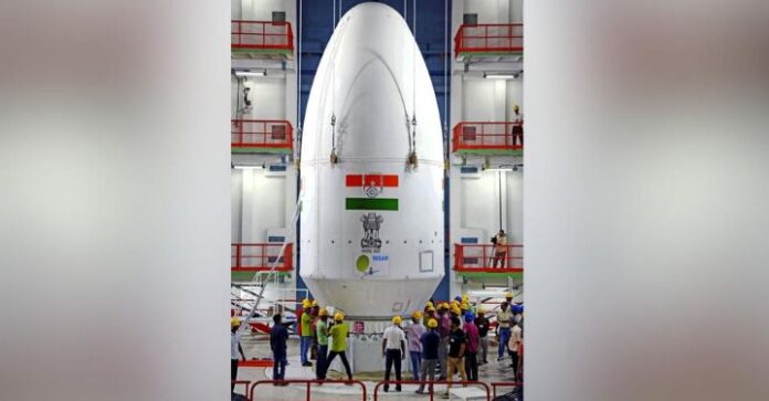
The countdown has begun for one of the most ambitious international Earth observation missions in history. The NASA-ISRO Synthetic Aperture Radar (NISAR) satellite is scheduled for liftoff on July 30, 2025, at 5:40 PM IST, marking a new era in space-based environmental monitoring. The ISRO chairman confirmed the date at a recent media briefing, reaffirming that preparations are complete for this landmark launch from the Satish Dhawan Space Centre, Sriharikota.
NISAR is the first satellite mission built by both NASA and ISRO, and it holds immense potential for climate science, natural disaster monitoring, and land use analysis. Beyond the technological achievement, the project symbolizes deepening collaboration between the United States and India in space science.
Dual Radar Technology: The Heart of NISAR
At its core, NISAR uses synthetic aperture radar (SAR) technology, a sophisticated system that emits microwave signals and measures their return to map Earth’s surface in high resolution. Uniquely, it features two radar frequencies:
- L-band radar: Provided by NASA, ideal for observing forests and penetrating dense vegetation.
- S-band radar: Built by ISRO, particularly effective for agricultural and urban analysis.
Together, these radars give NISAR the ability to “see” through cloud cover, darkness, and even canopy layers—offering near-constant, all-weather, day-and-night Earth imaging.
Key Specifications and Launch Details
- Launch Vehicle: ISRO’s GSLV F16 (Mk-II) rocket
- Launch Date & Time: July 30, 2025, at 17:40 IST
- Orbit: Sun-synchronous polar orbit at 743 km altitude
- Satellite Mass: ~2,400 kilograms
- Antenna: 12-meter deployable mesh reflector
- Swath Width: 240+ kilometers per pass
- Repeat Cycle: 12 days for complete Earth coverage
This system enables NISAR to detect ground movement as small as 1 centimeter, a key capability for monitoring landslides, earthquakes, and glacier movements.
Mission Goals and Global Benefits
NISAR’s applications are wide-ranging, making it one of the most anticipated environmental satellites in recent history:
1. Disaster Management
With its centimeter-scale resolution, NISAR will monitor tectonic shifts, land subsidence, and even subtle ground movement that precedes natural disasters. This will enhance early warning systems for earthquakes, volcanic eruptions, and landslides, potentially saving thousands of lives.
2. Climate and Cryosphere Monitoring
Scientists will use NISAR to study glacier flow, ice sheet stability, and permafrost thawing—critical indicators of climate change. With high-frequency observations, it can track the acceleration or slowdown of these phenomena in near real time.
3. Agriculture and Water Resource Management
In agriculture, NISAR can measure soil moisture, crop biomass, and irrigation levels, aiding precision farming. It can also monitor river systems, reservoir levels, and wetland health, making it vital for sustainable water usage.
4. Infrastructure Surveillance
Urban planners and engineers will benefit from data that can detect minute changes in buildings, dams, bridges, and roads, helping monitor structural integrity and identify vulnerabilities before failures occur.
5. Deforestation and Land Use Change
NISAR can assess forest cover, tree height, and biomass, supporting conservation efforts and enabling better management of carbon offsets and reforestation programs.
A Decade of Collaboration
The NISAR mission is the result of over 10 years of joint engineering, integration, and testing. NASA’s Jet Propulsion Laboratory (JPL) developed the L-band SAR, while ISRO contributed the S-band radar and the spacecraft bus.
The satellite underwent extensive thermal, mechanical, and antenna deployment tests before being shipped from California to Bengaluru in early 2024. It was later moved to Sriharikota for final integration with the GSLV launcher.
This cooperation sets a precedent for future joint planetary exploration, lunar missions, and deep space projects between the two countries.
Open Access to Data
A key feature of the NISAR mission is its open-data policy. The imagery and datasets will be publicly available, giving researchers, NGOs, government agencies, and even private companies access to a treasure trove of Earth science data.
“Making this data accessible ensures it will benefit not just scientists, but farmers, disaster responders, and environmentalists around the world,” said a senior ISRO official during a press conference.
Challenges Ahead
Despite its promise, NISAR’s success will hinge on:
- Successful deployment of its massive antenna in orbit
- Reliable power and thermal management systems for long-term functioning
- Timely data processing and distribution frameworks to make the insights actionable
ISRO and NASA have run simulations and redundancy tests to address these risks, with both agencies expressing full confidence in the mission’s readiness.
The Road to Launch
The launch pad at Sriharikota is now a hive of activity. Technicians are conducting final system checks, while the GSLV F16 rocket has passed all pre-launch qualifications. Meteorological forecasts for the launch window are also favorable, barring any last-minute weather anomalies.
Final Thoughts
With just days to go, NISAR represents more than just a satellite—it’s a scientific sentinel. It brings together the technical excellence of NASA, the engineering prowess of ISRO, and a shared commitment to using space for solving real-world problems.
Once in orbit, it will scan nearly every square inch of Earth every 12 days, offering humanity a new lens through which to observe, understand, and protect our planet.

